

Faults often have more than 1 slip surface to accommodate displacement. This blog presents an example of a fault with multiple slip surfaces along the coast from Arbroath, Scotland (Fig. 1). The fault brings Upper Devonian sediments into contact with Lower Devonian sediments at the nothern end of Carlingheugh Bay (Fig. 1). At the beginning of the outcrop section, near the car park (Whiting Ness, Fig. 1), there is a more well known contact between the 2 units; an angular unconformity (Fig. 2)(http://www.ogilviegeoscience.co.uk/blog/2017/7/30/scottishunconformitiesarbroath)

Figure 1. Map showing location of headland (white circle) at North end of Carlingheugh Bay, Arbroath. The fault of interest is the major one in the middle of the headland (shown by arrow on photograph).

Figure 2. Angular unconformity at Whiting Ness, Arbroath. Fig 1 for location.
The fault is the major fault in a series of faults cutting the headland on the N side of the bay (Fig. 1). It has 3 major slip surfaces and a large deposit of barite cement. (Fig. 3) The cement is spatially related to the fault suggesting that the fault acted as a conduit for the fluids that precipitated the cements. A close-up of the cements are shown in Fig. 4 showing white to pink coloured dendritic crystals and in other places, nodules within a sandy matrix (Fig 4b, 5). A map of barite occurrence shows barite occurrences just north of Arbroath [1]. It is likely related to Early Mesozoic magmatic and hydrothermal activity recognised in NW Europe and may be related to N Atlantic opening. The hydrothermal activity could be related to deep seated granites.

Figure 3. Major fault at North end of Carlingheugh Bay, Arbroath. Note the accumulation of cement in between the 1st and 2nd slip surfaces. The red arrow points to a marker used to determine displacement on the right hand slip surface.
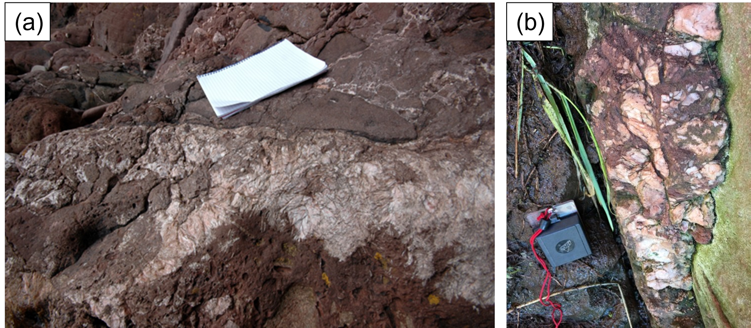
Figure 4. Fracture cements (a) barite has dendritic crystals, (b) more nodular mixed with sediments.

Figure 5 . View along fault plane showing fracture fill (location of Fig 4b).
The Lower Devonian is heavily fractured by joints (host rock on left hand side of Fig. 3). These are not present (to the same extent) in the Upper Devonian rocks. Therefore, they are older than the large fault which juxtaposes the two units. It is possible that they were created during Mid Dev tectonic activity. The lack of fractures in the Upper Devonian represents a tectonically quieter time after the Middle Devonian tectonic activity (responsible for e.g., the Sidlaw Hills inland).
Through the cave, following the fault plane, to the other side of this headland, the fault has been reduced to a single surface (Fig. 6); pinching out as shown on Fig 7 [2]. Here, a single slip surface appears to have been exploited by a more massive, dyke-like body. There are black veins running up and down within the dyke and a baked margin (few cm wide) on it’s contact with the host sandstone. Note the intensive fracturing in the Lower Devonian host sandstone on the right hand side - the fractures appear upwards directed towards the dyke. These overprint earlier joints in the L Devonian.

Figure 6. The single slip surface at the back of the fault is filled with cement. The structure is almost dyke-like with baked margins on the edges. Also illustrated is the highly fractured L Dev with further “dyke” related fractures.

Figure 7. Block diagram of a fault zone [2].
Another fault in Carlingheugh Bay, shows signs of a well connected fracture network at the time of cement precipitation (Fig. 8). The barite occurs together with galena in some fracture/veins (Fig. 9).

Figure 8. The white fracture fills highlight a well connected fracture network.

Fig. 9. Barite and galena fill a fracture N of Arbroath at Auchmithie.
Reference
[1] Cameron, I B, and Stephenson, D. 1985. British regional geology: The Midland Valley of Scotland. Third edition. Reprint 2014. Keyworth, Nottingham: British Geological Survey.
[2] Childs, C., Manzocchi, T.,Walsh, J. J., Bonson, C. G., Nicol, A. & Schopfer, M. P. J. 2009. A geometric model of fault zone and fault rock thickness variations. Journal of Structural Geology, 31, 117–127.